Exploring Mount Kilimanjaro
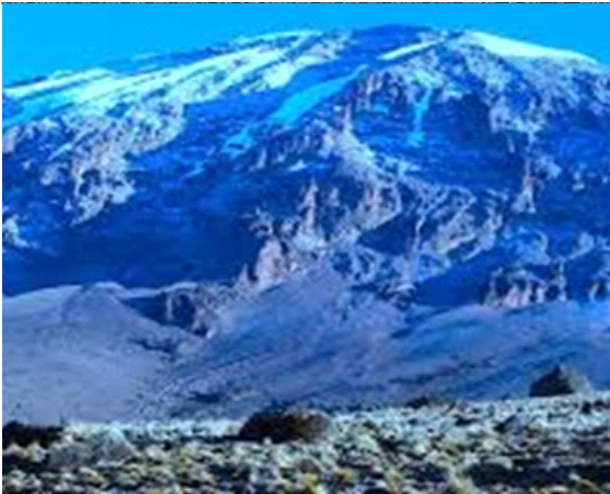
Mount Kilimanjaro is a dormant volcano located in Kilimanjaro Region of Tanzania. It has three volcanic cones: Kibo, Mawenzi, and Shira. It is the highest mountain in Africa and the highest single free- standing mountain above sea level in the world: 5,895 m above sea level and about 4,900 m above its plateau base.
Mount Kilimanjaro, located in Tanzania, is the highest peak in Africa and one of the most iconic and recognizable mountains in the world. Its history is not only geological but also cultural, as it has played a significant role in the region’s development.
Specifically, Mount Kilimanjaro is situated near the border between Tanzania and Kenya. The mountain is within Kilimanjaro National Park, which is a UNESCO World Heritage Site. The closest major town to Mount Kilimanjaro is Moshi, and the mountain is easily accessible from there. The geographic coordinates o f M o u n t K i l i m a n j a r o a r e approximately 3.0674° S latitude and 37.3556° E longitude.
Geologically, Mount Kilimanjaro is a stratovolcano formed through a series of volcanic activities over the past one million years. The mountain is actually a large volcanic massif composed of three distinct volcanic cones: Kibo, Mawenzi, and Shira.
Kibo is the highest and is dormant but not extinct, as evidenced by fumaroles and recent gas emissions near the summit.
Culturally the Chagga people, who have lived in the region for centuries, have a r i ch cultural h i stor y associated with Kilimanjaro. They considered the mountain to be sacred, and various legends and myths are tied to its existence.
E u r o p e a n e x p l o r e r s a n d missionaries in the 19th century were among the first outsiders to document the mountain. The first recorded ascent of Kilimanjaro was b y H a n s M e ye r a n d L u d w i g Purtscheller in 1889.
8 Amazing things to explore on Mt. Kilimanjaro
Foothills Waterfalls
The waterfalls are situated in the Kilimanjaro National Park, to the foothills of the Kilimanjaro. The source of the water comes directly from the glacier on top of Kilimanjaro. Splendid, green areas where also grow the most fantastic trees and exotic plants. About 40 minute drive from Moshi town, from which you have a very nice view on Mt. Kilimanjaro, located in the beautiful country side of Marangu surrounded by lush landscapes, you will find this hidden waterfall.
Lava Tower
Located a little over 15,000′ up the mountain along the Lemosho and Machame routes, Lava Tower is a large rock formation that (you guessed it) was formed from lava, back in the days when Kilimanjaro was still an active volcano (though Kili is dormant these days, and hasn’t had a major eruption in around 150,000 years, fumaroles near the summit crater still emit gases, and there was volcanic activity on the mountain just 200 years ago).
Karanga Valley
The Karanga Valley is a low-lying land between some hills on Mount Kilimanjaro with a stream of water flowing through it which also happens to be the last point that porters fetch water to drink and use for cooking. This valley game the camp next to it, the Karanga camp, its name.
The Karanga Valley is located at an altitude of about 4,100m. This valley can be found just a er the Baranco wall and right before the Karanga camp, South of Uhuru Peak on Kibo.
Lava Tower
Lava Tower is what’s known as a volcanic plug; at some point in the distant past, lava shot out a vent at the base of where Lava Tower now stands, cooled, and hardened, thus stopping up the vent beneath. On active volcanoes, plugs like these can increase pressure below the surface, leading to more explosive eruptions
Shira Plateau
Placed on the slopes of Kilimanjaro, the Shira Plateau shows the remains of an ancient caldera, a volcanic crater that expired around half a million years ago. Today, it stands as a World Heritage Site, boasting deep valleys and weather-beaten lava flows. These are wonderfully framed near the Kibo Massif, which resembles twisted, modern sculptures.
The Shira Plateau, located near Simba Riva on top of the Shira Peak, which is the third highest peak on Mouth Kilimanjaro a er Mawenzi and Kibo, covers an extensive distance of 13 kilometres (8 miles) to the west of Kibo, at an elevation of 3,962 metres (12,999 ).
Perched on the slopes of Mount Kilimanjaro, the Shira Plateau has an array of displays on offer including of an ancient caldera, a volcanic crater that expired about 500 million years ago.
Uhuru Peak
Uhuru Peak is the highest point on the rim and at an altitude of 5,895m, the highest point in all Africa. Uhuru peak is the summit of Mount Kilimanjaro, located on Kibo in the arctiz zone of Kilimanjaro. The peak is perched on one of the peaks on the mountain that consists of Kibo, Mawenzi, and Shira. Its name comes from the Swahili word freedom ‘Uhuru’.
Stella Point
Stella Point at an altitude of 5,756 meters (18,885 feet) is one of three official summit points on Mount Kilimanjaro. Coming from ‘Gilmans Point one passes Stella Point on the way to the actual summit of Kilimanjaro, Uhuru Peak at (5,895 meters (19,341 feet). Stella Point is situated at the edge of the crater rim.
Great Barranco Wall
Barranco Wall is a steep ridge roughly halfway up Mount Kilimanjaro. It lies at the southern base of Kilimanjaro’s main peak, Kibo. This imposing feature of the famous mountain formed long ago when Kilimanjaro was still an active volcano.
Kilimanjaro National Park
Kilimanjaro National Park is a Tanzanian national park located 300 kilometers (190 miles) south of the equator and in Kilimanjaro region, Tanzania. The park is located near the region of Moshi. The park includes the whole of Mount Kilimanjaro above the tree line and the surrounding montane forest belt above 1,820 meters (5,970 .). It covers an area of 1,688 square kilometers (652 sq. mi), 2°50’–3°10’S 37°10’–37°40’E.
The park is administered by the Tanzania National Parks Authority (TANAPA). It was established as a national park in 1973.
A variety of animals can be found in the park. Above the timberline, the Kilimanjaro tree hyrax, the grey duiker, and rodents are frequently encountered. The bushbuck and red duiker appear above the timberline in places. Cape buffaloes are found in the montane forest and occasionally in the moorland and grassland. Elephants can be found between the Namwai and Tarakia rivers and sometimes occur at higher elevations. In the montane forests, blue donkeys, eastern black and white colobuses, bush babies, and leopards can be found.
Routes of Climbing Kilimanjaro Lemosho Route
This is a more relaxed route. It is suitable for 8 days for acclimation and it has a good balance in the height of the camp sites. The view is really charming while passing through forests.
Machame Route
It is the most popular route and the busiest among all. In terms of popularity, it has taken over the Marangu Route.
Northern Circuit
This route is for mountain lovers and those who are solitude seekers. It is a 9 day climb. Although visitors can take the route in only 8 days, 9 days is more relaxed. It is already a hard thing to come by on Mount Kilimanjaro Tanzania, but this is a welcome bonus to the Northern Circuit route.
Rongai Route
This is the best route for climbing the mountain in 6 days. It begins the ascent up the northern side of the mountain. In terms of scenery and summit success, it is unparalleled.
There is flexibility in this route as well. One can add an extra day for acclimatization and increasing the success chance of climbing.
Shira Route
This route will take you through the beautiful scenery and wilderness of Shira Plateau and around the hilly and beautiful Moir Hut and the Lent Hills. It is an 8 day itinerary road, through which the summit is approachable from the western side. It is excellent for those who want uninterrupted time and away from the crowds.